
May 16th – 22nd, 2026
East Side V West Side: Which Side of Glacier is Better?


East Side
Many Glacier, St. Mary, Two Medicine, and East Glacier
Camping
- St. Mary Campground: A five minute walk or one minute drive from the East entrance and town of St. Mary for $30 a night; We went preseason, so there was no potable water available in the campground and the restrooms weren’t open yet. The campground sites have fire pits and picnic tables – and peep those Red Eagle Mountains looming in the background.

Bites
We went preseason, so a lot of what the town of St. Mary had to offer was still closed; however, don’t let this discourage you. There are still amenities available. You just need to drive a bit further to get to them.
- Kyiyo Mercantile & Bakery: Free Wi-Fi. Repeat. Free Wi-Fi. There is very limited service in the park, and with the St. Mary visitor center still closed for the season, we were blessed to discover Kyiyo. They offer craft coffees/lattes, made in house pastries, hot sandwiches, souvenirs and are only 30 minutes from the East park entrance. No indoor seating, but plenty of picnic tables outside.
- St. Mary Grocery Store: Right outside of the East park entrance, they have plenty of meats, produce, firewood, kombuchas, souvenirs, and stickers. Basically anything you’ll need while exploring East Glacier.
- First Light Espresso: In the town of East Glacier, this coffee barn is roughly 50 minutes from the East park entrance. Unless you are going to or through East Glacier (the town, confusing I know), I wouldn’t say it is worth the drive, but if you are – it is worth the stop. We were in East Glacier renting mountain bikes, so it was convenient for us, and we noticed a few other restaurants while there that you could check out.


Hikes
Even in late May, many of the trails were still snow covered or were unaccessible due to the seasonal road closures. With that being said, can we truly choose which side of Glacier is better? Short answer: yes. Long answer: keep reading.
Two Medicine Area
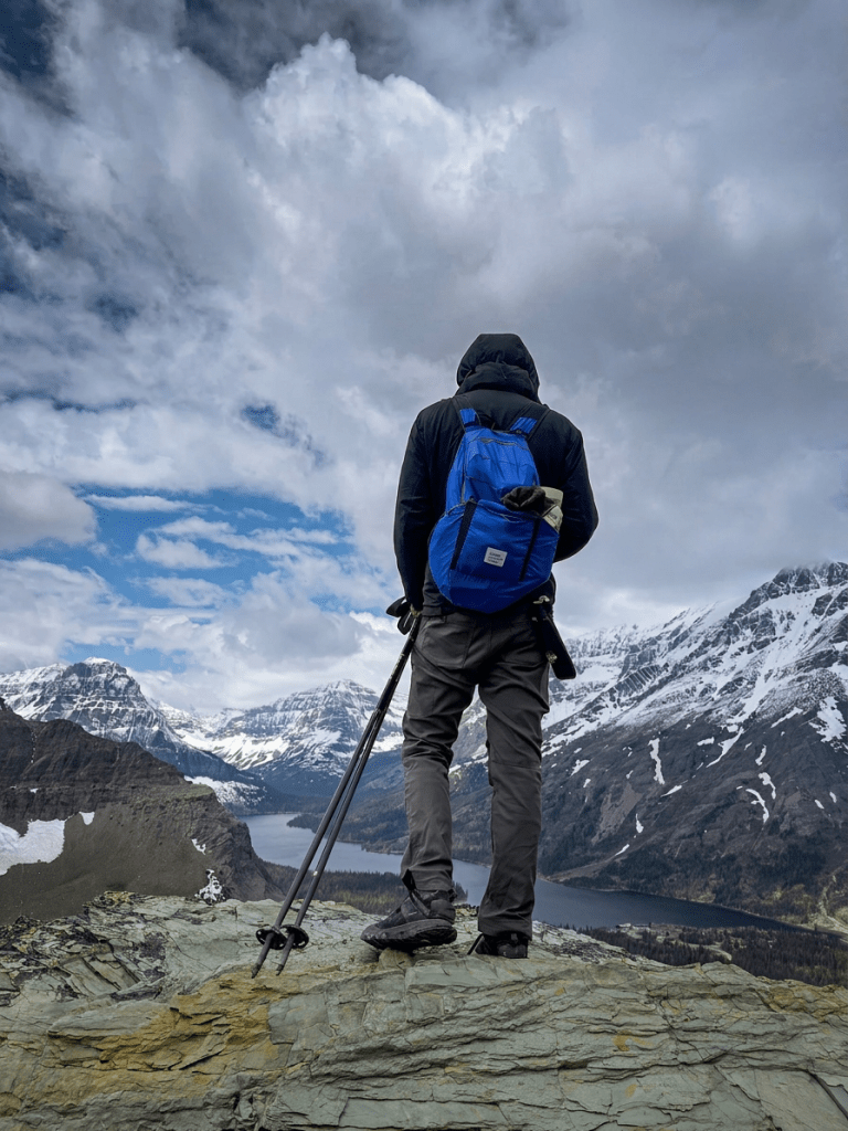
- Scenic Point via Mt Henry/Continental Divide Trail: A moderately strenuous 8 mile in and out peak hike with 360 views, lots of wildlife (sheep, marmots), and a short spur trail that offshoots to Appistoki Falls.
- Running Eagle Falls: A short 0.5 mile loop with interpretive signs on native flora along the way; FYI: If you want to get to the base of the falls, you’ll have to scramble over logs and rocks to cross the river because the bridge is currently out.
- Next time – Rockwell Falls: Because of rain, we did not get to do Rockwell Falls, but it is on our ‘For Next Time’ list.
Along Going-to-the-Sun Road (seasonally closed after Siyeh Bend to all traffic)
- Baring, St. Mary, and Virginia Falls via Piegan Pass Trail: A moderate 6.5 mile in and out that passes by three iconic waterfalls and includes views of St. Mary Lake; This trail was crowded, and parking was slim.
- Jackson Glacier Overlook: A quick stop-and-go pullout; No hate, but I have seen a lot of glaciers, so this one wasn’t the most impressive, but when in Glacier!
- Next time – Hidden Lake: Boo road closures! But we need things to do when we come back, so c’est la vie.
Many Glacier Area
- Grinnell Glacier via the Swiftcurrent Lake Trail: A strenuous 11 mile in and out trail; Even in late May this trail was still snow covered and impassible (lots of snow bridges – ek, no thanks), so for our safety, we decided to stop about 1.5 miles away from the glacier and turn around; Even though we didn’t make it all the way to the glacier, this trail was EPIC. Three lakes, a hidden waterfall, bears. We did take the lower Grinnell Glacier Lake spur too- worth it to see Hidden Falls and Grinnell Lake up close, but because the bridge was out on the lake spur, we had to scrabble over logs and rocks to cross the river, so be aware.
- Next time – Iceberg Lake and the Waterton Area: Rangers told us we wouldn’t be able to access Iceberg Lake yet, so we didn’t attempt it and because of time, we weren’t able to get to the Waterton Area, but I have only heard how Waterton is a must-do when we return – with someone we met recently claiming Waterton has, “the best hikes in Canada!”.
Biking
Truthfully, I wouldn’t waste the time or money biking in East Glacier. It isn’t very biker friendly (I couldn’t find any formal bike paths in the area) and to rent bikes we had to drive nearly an hour to the town of East Glacier to Rising Wolf Outfitters (and don’t forget the hour drive back to drop the bikes off). We paid $100 a day for their standard mountain bikes plus $20 a day for the hitch to tote the bikes around. Books, Bites, Insights? If you’re interested in biking, save it for West Glacier.




West side
Lake McDonald, Apgar, West Glacier, and Kalispell
Camping
- Apgar Campground: A 5 minute drive from West Glacier and a 5 minute walk to the Apgar Village (shops, cafes, bike rentals) for $30 a night; Amory and I made peanut butter s’mores in our fire ring, and even though the showers were closed, there was running water and flush toilets. There was limited cell service, but Apgar Campground was one of the few places in Glacier NP where we were able to get one or two bars.
- Sprague Creek Campground: My favorite campground in Glacier. Small, snug. Sprague Creek gives much more secluded vibes than St. Mary or Apgar. The campground is accommodating with flush toilets, picnic table, fire ring, and potable water all for $30 a night. And the best part, Sprague Creek is conveniently located close by many of the popular hikes in West Glacier.


Hikes
- Avalanche Lake Trail: An easy 6 mile in and out trail along Avalanche Creek through cedar and hemlock trees leading to (on a clear day) a reflective lake nestled among mountainsides; Because this is a Glacier must-do, it can be very crowded during peak season/times.
- Stanton Mountain Trail: A very strenuous 8 miles out and back trail but arguably one of the best peak hikes in West Glacier that is accessible preseason; This trail is less traversed and slightly abandoned. TBH the trail conditions and markings are poor, but don’t let that effect you doing the thing. Just use AllTrails. Trust me, this one is worth it. How many others can say they saw Lake McDonald at 8,000 feet elevation?
- Johns Lake Loop: A quick and gentle kid-friendly 2 mile loop through the forest with connecting trails to the Upper McDonald Creek trails
- Rocky Point: An easy 2 mile out and back trail that give you different view points of Lake McDonald
- Upper McDonald Creek Trail: A peaceful 5.5 mile out and back trail that follows McDonald Creek and includes McDonald Falls.
- Notch Trail, Overlook Trail, and Plum Creek Road Loop in Kalispell: A 4 mile loop in Kalispell (50 minute drive from West Glacier) that take you to an overlook of Foy’s Lake; Don’t go out of your way for this trail, but if you’re looking for something to do in the Kalispell area, it is a solid trail.
- Next time – Apgar Lookout, Polebridge, Whitefish: Due to time, we did not make it to the Polebridge Area of the park or to the recommended town of Whitefish; If you’ve been to either, let me know what your thoughts were/are in the comments below – still gauging if we should include time for either when we return.


Bites
- Phở Hà Nội in Kalispell: A 45 minute drive for pho? You already know Amory and I will lol. And we did. Twice. No shame. And we wouldn’t of went back, but damn was Phở Hà Nội’s pho authentic.
- West Glacier Mercantile in West Glacier town: Kombuchas, kombuchas, and more kombuchas. And local kombuchas at that. We tried a handful of kombuchas during our time in West Glacier from locally (Montana) made kombucha from Nourishing Cultures to the slightly less locally (Oregon) made kombucha from Happy Mountain. My personal favorite was the Mountain Berry Dream from Nourishing Cultures. Crisp. Fruity. Bold. Hydrating post-hike drink. And can be enjoyed in the sunshine on West Glacier Mercantile’s patio.
- Cedar Tree Gift Shop in Apgar Village: Hot coffee and local caramel cookies. Need I say more? Nope. Seriously the handmade stoopwafels from Carmel Cookie Waffles will be in everyone’s stocking this year. Support local. Visiting their cafe in Billings is now on my bucket list.


Biking
If you’re wanting to bike in Glacier, the West side is the side to bike. We were able to easily and safely bike Going-to-the-Sun road because it was still closed to shuttles and cars; however, it wasn’t completely open to bikers or pedestrians either – closed after The Loop to anyone and everyone. When planning a trip to Glacier, my Books, Bites, and Insights would be to figure out your Glacier musts, see when those are doable in the capacity you want to do them (hiking, biking, or driving), and plan your trip around that. Otherwise, you may leave feeling disappointed.
We rented standard mountain bikes and a hitch from Glacier Outfitters in the Apgar Village for $60 a day. Would I recommend the standard mountain bike? Not if you don’t want to struggle. I am in fairly good shape, but 8 miles of continuous elevation gain is tough. But don’t fret! E-bikes are available for $135 a day.
- Going-to-the-Sun Road: An 8 miles bike ride up from Avalanche Campground – with lots of elevation gain aka it isn’t easy on a standard mountain bike, but it is doable – I promise. In fact, we went twice because the first time we went up it was cloudy. The second time we went up we decided to squeeze it in at sunset and were glad we did because we saw so many bears on the way down. Even a momma with two cubs!
- Apgar Bike Path: A 4 mile out and back paved trail that starts at the Apgar Visitor Center and takes you into the town of West Glacier.
- Fish Creek Bike Path: A 2 mile out and back partially paved, partially unpaved trail that connects the Apgar Bike Path and the Fish Creek Campground.
All in all, with biking, I was disappointed at Glacier. So many people had talked up the biking in Glacier, so maybe I just had high expectations, but Glacier wasn’t as biker friendly as I had imagined. Going-to-the-Sun road was breathtaking, but if the road was open to cars, I would not feel comfortable biking it. Additionally, the bike trails around the park were neither abundant nor marked well. I hate to be a hater, but the park just didn’t live up to the biker’s paradise others had made it out to be.


So which is better? For me personally, the East. And if I was returning, I would only plan my visit around returning to and staying in East Glacier. However, if the entire Going-to-the-Sun road was open, I wouldn’t be opposed to driving it in its entirety.
Let’s break it down: West Glacier has the famous stuff (Lake McDonald, Avalanche Lake, the Village with all the shops), isn’t as remotely located for those who need their creature comforts, is open year-round, and is generally more accessible. But it’s crowed, lacks those grandiose peak hikes that I yearn for, and, IMO, doesn’t live up to the hype.
East Glacier though. Shew. I could spend another week there (and will, fingers crossed) and still feel incomplete. Will you be driving more? Sure. Can you get a hot oat milk latte as easily? No. But for an avid hiker, the East side of Glacier National Park delivers – as promised.
Before you go, if you’ve explored Glacier NP yourself, please let me know below what your favorite side is and why. Did we miss anything? If so, share! We plan to go back next July, and I will personally shout you out if you lead us in the right direction.
Xoxoxoxoxoxoxox and xo reader. Blessings and peace. Until next week.


Leave a Reply